paulhammond5155

joined 1 year ago
 

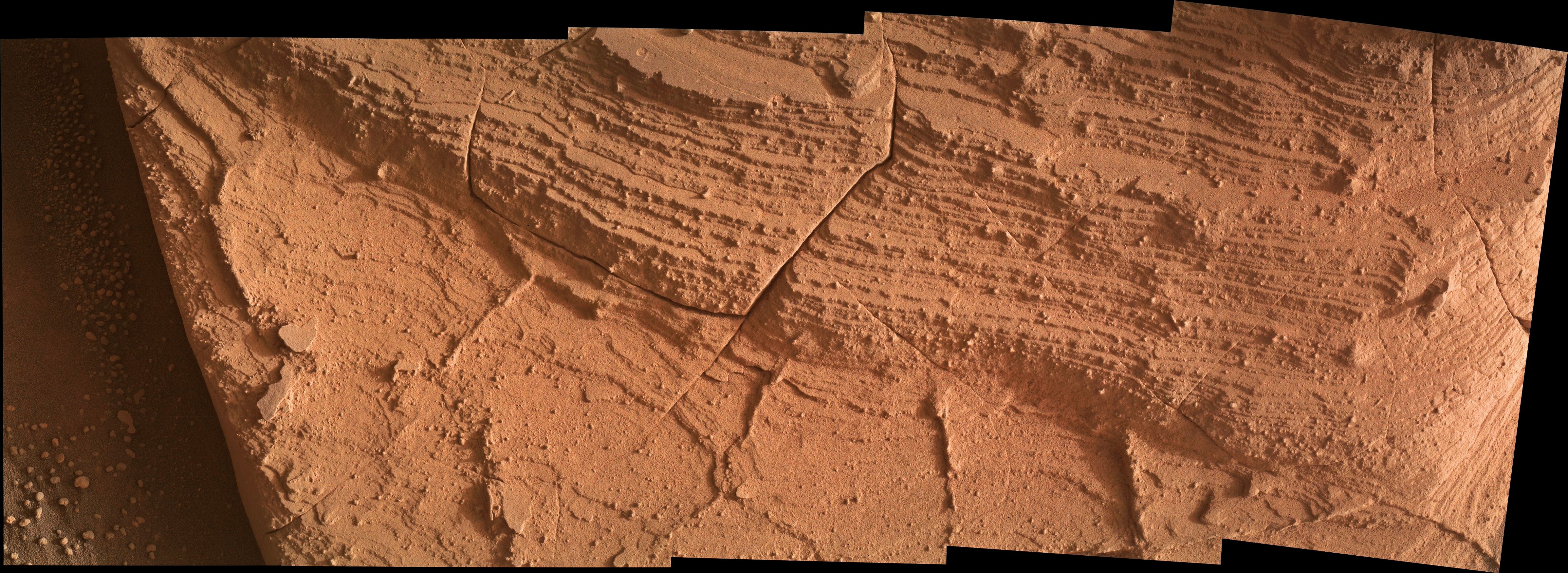
The camera standoff was ~25 centimeters (~10 inches).

A 25 cm standoff provides an image scale of ~95 micrometers per image pixel, or a scene height of ~15 centimeters (~6 inches), width ~45 cm (~18")

4789 x 1748 pixels

Image Credits: NASA/JPL-Caltech/MSSS.


Curiosity rover used one of its Mast Camera to capture this last look at a section of the field of bright white sulfur stones before leaving Gediz Vallis channel. The field was where the rover made the first discovery of pure sulfur on Mars by driving over a rock and cracking it open to reveal the yellow crystals inside. Scientists are still unsure exactly why these pure sulfur rocks formed here. This composite is made up of several overlapping images captured on October 11, 2024 (Sol 4331). Image Credit: NASA/JPL-Caltech/MSSS


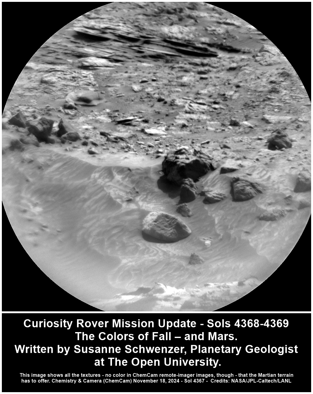
Curiosity Rover Mission Update - Sols 4368-4369: The Colors of Fall – and Mars. Earth planning date: Monday November 18, 2024.

I am in the U.K., where we are approaching the time when trees are just branches and twigs. One tree that still has its full foliage is my little quince tree in my front garden. Its leaves have turned reddish-brown with a hint of orange, fairly dark by now, and when I passed it this afternoon on my way to my Mars operations shift, I thought that these leaves have exactly the colors of Mars! And sure enough, today’s workspace is full of bedrock blocks in the beautiful reddish-brown that we love from Mars. But like that tree, it’s not just one color, but many different versions and patterns, all of many reddish-brown and yellowish-brown colors.

The tree theme continues into the naming of our targets today, with ChemCam observing the target “Big Oak Flat,” which is a flat piece of bedrock with a slightly more gray hue to it. “Calaveras,” in contrast, looks a lot more like my little tree, as it is more reddish and less gray. It’s also a bedrock target, and APXS and MAHLI are observing this target, too. APXS has another bedrock target, called “Murphys” on one of the many bedrock pieces around. MAHLI is of course documenting Murphys, too. Let’s just hope that this target name doesn’t get any additions to it but instead returns perfect data from Mars!

ChemCam is taking several long-distance remote micro-imager images — one on the Gediz Vallis Ridge, and one on target “Mono Lake,” which is also looking at the many, many different textures and stones in our surroundings. The more rocks, the more excited a team of geologists gets! So, we are surely using every opportunity to take images here!

Talking about images… Mastcam is taking documentation images on the Big Oak Flat and Calaveras targets, and a target simply called “trough.” In addition, there are mosaics on “Basket Dome” and “Chilkoot,” amounting to quite a few images of this diverse and interesting terrain! More images will be taken by the navigation cameras for the next drive — and also our Hazcam. We rarely talk about the Hazcams, but they are vital to our mission! They look out from just under the rover belly, forward and backward, and have the important task to keep our rover safe. The forward-looking one is also great for planning purposes, to know where the arm can reach with APXS, MAHLI, and the drill. To me, it’s also one of the most striking perspectives, and shows the grandeur of the landscape so well. If you want to see what I am talking about, have a look at “A Day on Mars” from January of this year.

Of course, we have atmospheric measurements in the plan, too. The REMS sensor is measuring temperature and wind throughout the plan, and Curiosity will be taking observations to search for dust devils, and look at the opacity of the atmosphere. Add DAN to the plan, and it is once again a busy day for Curiosity on the beautifully red and brown Mars. And — hot off the press — all about another color on Mars: yellowish-white!

Written by Susanne Schwenzer, Planetary Geologist at The Open University

Source for this blog and the archive of all blogs (with all the links and the original raw images etc) https://science.nasa.gov/blog/sols-4368-4369-the-colors-of-fall-and-mars/

These blog updates are provided by self-selected Mars Science Laboratory mission team members who love to share what Curiosity is doing with the public.

Dates of planned rover activities described in these reports are subject to change due to a variety of factors related to the Martian environment, communication relays and rover status.

Image credits: NASA/JPL-Caltech/LANL


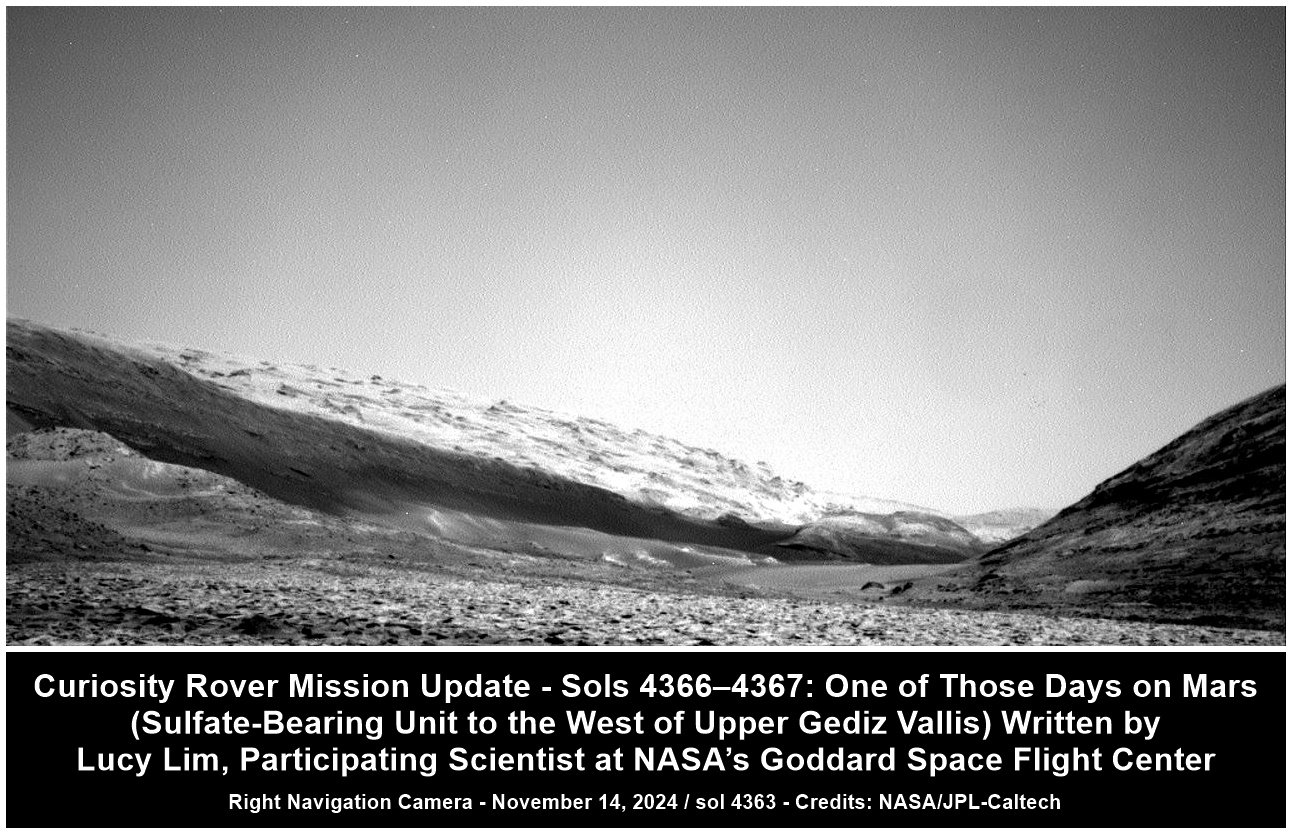
Curiosity Rover Mission Update - Sols 4366–4367: One of Those Days on Mars (Sulfate-Bearing Unit to the West of Upper Gediz Vallis).

Earth planning date: Friday November 15, 2024.

The Monday plan and drive had executed successfully, so the team had high hopes for APXS and MAHLI data on several enticing targets in the rover's workspace. Alas, it was not to be: The challenging terrain had resulted in an awkwardly perched wheel at the end of the drive, so we couldn't risk deploying the arm from this position. Maybe next drive!

We did plan a busy weekend of non-arm science activities regardless. Due to a “soliday” the weekend has two sols instead of three, but we had enough power available to fit in more than three hours of observations. The two LIBS observations in the plan will measure the composition of the flat, reddish material in the workspace that is fractured in a polygonal pattern (“Bloody Canyon”) and a nearby rock coating in which the composition is suspected to change with depth (“Burnt Camp Creek”). One idea is that the reddish material could be the early stage version of the thicker dark coatings we've been seeing.

A large Mastcam mosaic (“Yosemite”) was planned to capture the very interesting view to the rover's north. Nearby and below the rover is the layer of rocks in which the “Mineral King” site was drilled on the opposite side of the channel back in March. This is a stratum of sulfate-bearing rock that appears dark-toned from orbit and we're interested to know how consistent its features are from one side of the channel to the other. Higher up, the Yosemite mosaic also captures some deformation features that may reveal past water activity, and some terrain associated with the Gediz Vallis ridge. So there's a lot of science packed into one mosaic!

Two long-distance RMI mosaics were planned; one is to image back into the channel, where there may be evidence of a late-stage debris flow at the base of the ridge. The second looks “forward” from the rover's perspective instead, into the wind-shaped yardang unit above us that will hopefully be explored close-up in the rover's future. This yardang mosaic is intended to form one part of a stereo observation.

The modern environment on Mars will also be observed with dust devil surveys on both sols, line-of-sight and tau observations to measure atmospheric opacity (often increased by dust in the atmosphere), and zenith and suprahorizon movies with Navcam to look for clouds. There will also be standard passive observations of the rover's environment by REMS and DAN.

We'll continue driving westward and upward, rounding the Texoli butte to keep climbing through the sulfate-bearing unit. It's not always easy driving but there's a lot more science to do!

Written by Lucy Lim, Participating Scientist at NASA’s Goddard Space Flight Center

Source for this blog and the archive of all blogs (with all the links and the original raw images etc) https://science.nasa.gov/blog/sols-4366-4367-one-of-those-days-on-mars-sulfate-bearing-unit-to-the-west-of-upper-gediz-vallis/

These blog updates are provided by self-selected Mars Science Laboratory mission team members who love to share what Curiosity is doing with the public.

Dates of planned rover activities described in these reports are subject to change due to a variety of factors related to the Martian environment, communication relays and rover status.

Image credits: NASA/JPL-Caltech


Mosaics / video and a good write up


This image was taken by the MARDI camera onboard NASA's Mars rover Curiosity on Sol 4363 (November 14, 2024) just after 8am local Mars Solar Time.

The Mars Descent Imager (MARDI) acquired hundreds of natural colour images at a rate of 4 frames per second during Curiosity’s descent to the Martian surface on August 6th, 2012.

Still operational on the surface of Mars, MARDI is now used to image under the rover to support science and engineering activities.

Credits: NASA/JPL-Caltech/MSSS


Assembled from 15 overlapping L-MastCam images acquired on November 13, 2024. Bayer reconstruction by fredk

Credits: NASA/JPL-Caltech/MSSSS/fredk


The 4360 drive path is highlighted in yellow


15 overlapping Bayer reconstructed L-MastCam frames.

Credits: NASA/JPL-Caltech/MSSS/fredk


Curiosity Rover - Sols 4359-4361: The Perfect Road Trip Destination For Any Rover! Earth planning date: Friday November 8, 2024.

After the excitement of Wednesday’s plan, it was a relief to come in today to hear that the drive toward our exit from Gediz Vallis completed successfully and that we weren’t perched on any rocks or in any other precarious position. This made for a very smooth planning morning, which is always nice on a Friday after a long week.

But that isn’t to say that Curiosity will be taking it easy for the weekend. Smooth planning means we have lots of time to pack in as much science as we can fit. Today, this meant that the geology group (GEO) got to name eight new targets, and the environmental group (ENV) got to spend some extra time contemplating the atmosphere. Reading through the list of target names from GEO felt a bit like reading a travel guide — top rocks to visit when you’re exiting Gediz Vallis!

If you look to the front of your rover, what we refer to as the “workspace” (and which you can see part of in the image above), you’ll see an array of rocks. Take in the polygonal fractures of “Colosseum Mountain” and be amazed by the structures of “Tyndall Creek” and “Cascade Valley.” Get up close and personal with our contact science targets, “Mahogany Creek,” “Forester Pass,” and “Buttress Tree.” Our workspace has something for everyone, including the laser spectrometers in the family, who will find plenty to explore with “Filly Lake” and “Crater Mountain.” We have old favorites too, like the upper Gediz Vallis Ridge and the Texoli outcrop.

After a busy day sightseeing, why not kick back with ENV and take a deep breath? APXS and ChemCam have you covered, watching the changing atmospheric composition. Look up with Navcam and you may see clouds drifting by, or spend some time looking for dust devils in the distance. Want to check the weather before planning your road trip? Our weather station REMS works around the clock, and Mastcam and Navcam are both keeping an eye on how dusty the crater is.

All good vacations must come to an end, but know that when it’s time to drive away there will be many more thrilling sights to come!

Written by Alex Innanen, Atmospheric Scientist at York University

Source for this blog and the archive of all blogs (with all the links and the original raw images etc) https://science.nasa.gov/blog/sols-4359-4361-the-perfect-road-trip-destination-for-any-rover/

These blog updates are provided by self-selected Mars Science Laboratory mission team members who love to share what Curiosity is doing with the public.

Dates of planned rover activities described in these reports are subject to change due to a variety of factors related to the Martian environment, communication relays and rover status.

Image credits: NASA/JPL-Caltech


Curiosity assembled this focus stacked product using images from its Mars Hand Lens Imager (MAHLI), located on the turret at the end of the rover's robotic arm, on November 11, 2024, Sol 4360. The base images were acquired one sol earlier (4359). The camera focus motor count returned with the first image has been used to estimate the camera standoff distance (camera lens to the target). In this case the standoff was ~25 centimeters (~10 inches). That standoff provides an image scale of ~95 micrometers per image pixel, or a scene width of ~15 centimeters (~6 inches). Image Credits: NASA/JPL-Caltech/MSSS.

[–] paulhammond5155@lemmy.world 2 points 2 weeks ago

I wish you faster speeds in the future, it holds some wonderous images and data. Take care :)

[–] paulhammond5155@lemmy.world 2 points 2 weeks ago (2 children)

Milly’s Foot Path

The rover is in a map quadrangle called 'Bishop', so all targets are named after Bishop in Owens Valley (California)

Milly’s Foot Path is a path through a rugged chute full of broken rocks . See image on https://www.flickr.com/photos/psa104/15269986920

I guess a member of the MS team may have ventured up that path at some time in the past....

"A Climber's Guide to the High Sierra" page 221 gives a fair account of the passes and identifies their namesakes as Lucy Brown, wife of Bolton Coit Brown who crossed the divide in 1896. Milly's is named for Mildred Jentsch who with Sylvia Kershaw crossed the saddle just north of Mt. Genevra in July 1953.

Here's how they assign names based on map quadrangles....

Before touching down in Gale crater Curiosity's landing ellipse and the foothills of Aeolis Mons (Mt. Sharp) were divided up into 151 map quadrangles to aid geological mapping. Each of these square areas of interest spans 0.025 degrees in latitude by 0.025 degrees in longitude, each quadrangle measures about 1.5 kilometers square or about 1.22 x 1.22 km. Each quadrangle is assigned a name of a town with a population less than 100,000 people.

Map quadrangles are usually named after towns close to notable regions of geological interest on Earth, its name then provides the source of the target names within each quadrangle.

List of Quadrangles the rover has visited:-

Yellowknife: Quadrangle #51: Yellowknife a city in northwestern Canada as well as group of rocks from the same region. The rocks were formed 2.7 billion years ago from both volcanoes and sediments laid down by water, and were deposited over 4-billion-year-old rocks, the oldest known on Earth.

Mawson: Quadrangle #65: Mawson, Antarctica, permanent base and research outpost in Antarctica, named after the Antarctic geologist and explorer Sir Douglas Mawson.

Coeymans: Quadrangle #64. Takes its name from the town of Coeymans in upstate New York, located near the fossil‐rich Coeymans Limestone Formation.

Kimberley: Quadrangle #78. Takes its name from the northernmost region of Western Australia, the site of many important geologic investigations of Precambrian rocks.

Hanover: Quadrangle #77, Takes its names from a New Hampshire city.

Shoshone: Quadrangle #91. Takes its name from Shoshone Village in Inyo County, California located just outside Death Valley National Park and the Nopah Range Wilderness Area.

Arlee: Quadrangle #90. Takes is name from after a geological district in Montana

Windhoek: Quadrangle #104. Takes its name from a geological district in Namibia.

Bar Harbor: Quadrangle #118 Takes its name from Bar Harbor, Maine

Kuruman: Quadrangle #132. This quadrangle is named after a charming town situated on the edge of the Kalahari desert in South Africa. Notably, the town of Kuruman is the namesake for the Kuruman Iron Formation, a ~2.46 billion year sedimentary rock that is rich in hematite. Hematite is the same mineral we can see is distributed throughout the Vera Rubin Ridge from orbital data! The target names in this quadrangle are pulled from famous geological features from South Africa and nearby Botswana and Zimbabwe.

Biwabik: Quadrangle #119, the Biwabik name was selected because of the city's connection with the Mesabi Range, which contains large deposits of Precambrian iron ore.

Torridon: Quadrangle #133, Named after a village in the Northwest Highlands of Scotland, which is near an important geological formation called the Torridonian Supergroup. Therefore, all of the names assigned to targets in this region of Curiosity's traverse come from landforms, geologic formations, and towns in that part of Scotland.

Nontron: Quadrangle #134, 'Nontron' is named after a commune in the Dordogne in southwestern France. The Nontron quadrant name is particularly appropriate for the clay-bearing terrain we find ourselves in as Nontron is the type locality for a clay mineral called nontronite. Nontronite is part of the smectite group of clays, which are the most common types of clays on Mars.

Roraima: Quadrangle #147. The Roraima quadrant is named after the northern-most state of Brazil and Mount Roraima, which is the highest peak in the Pakaraima mountains which sits between Brazil, Venezuela, and Guyana. The terrain in the Roraima region on Earth looks somewhat similar to the area Curiosity is in - with flat-topped hills and some steep slopes.

Kalavryta: Quadrangle #148 Kalavryta is named after a town in Greece, due west of Athens and near the Chelmos-Vouraikos UNESCO Global Geopark, a region that consists of 40 unique geological sites including caves, karstic springs, rivers, alpine lakes, and fossil sites.

Bishop: (Current Quadrangle) Bishop California is located in Owens Valley, and is the starting point for trips into the High Sierra, including some awesome geology. It feels like a fitting name for this part of Curiosity’s ascent of Mt. Sharp!
[–] paulhammond5155@lemmy.world 2 points 1 month ago

They couldn’t spring for the S-VDB?

Those S-VDB's are a tad pricey 😂 😂 😂

I'd hate to think what a numismatist with deep pockets would pay for that VDB, if it was ever brought home, no matter what its PCGS grade ... 🤯

[–] paulhammond5155@lemmy.world 2 points 1 month ago

Wonder if it’s something they will consider changing in the designs of future rovers. They already changed the design for the Perseverance rover, it has more grousers and a different pattern for those grousers. those redesigned wheels have been on Mars for 1279 sols (so far) and have zero damage.

Here's a short video clip that goes over the changes https://youtu.be/ov_TXfWBf-4?t=68

[–] paulhammond5155@lemmy.world 7 points 1 month ago

why isn’t the wheel solid?

  • Weight is an issue
  • The wheels were the rover shock absorbers during landing (by the sky-crane back in 2012)
  • Yes, no passenger comfort, but there is an amount of sensitive electronics and instruments to protect.
[–] paulhammond5155@lemmy.world 19 points 2 months ago

Several years ago they did an engineering study that basically stated that when a specific number of cleats broke it had used up a percentage of its life. We're past that stage now. They have since developed a scenario that will allow them to rip one half of the damaged wheel off, and still drive on the remaining half.... All of the wheels are motorized, losing one wheel won't stop the rover from traversing to it's science waypoints

[–] paulhammond5155@lemmy.world 2 points 2 months ago

I'd like to hope so. One could assume that it would be a prerequisite to any crewed missions, so fingers crossed for a high-speed / volume DSN in my lifetime ☺️

[–] paulhammond5155@lemmy.world 2 points 2 months ago

The Martian hand is considered tame compared with the NSFW traverse inside Neretva Vallis by Perseverance rover 😂

[–] paulhammond5155@lemmy.world 2 points 2 months ago

The public can access the mission map on this URL. It is updated by the mission team after each drive https://mars.nasa.gov/maps/location/?mission=Curiosity

[–] paulhammond5155@lemmy.world 3 points 2 months ago

I would hope they do a mix of "old world" and 'new' world names 😁

The dump is a text file i've updated as the mission progressed. Saves me time when I get asked the question re place names.

[–] paulhammond5155@lemmy.world 3 points 2 months ago (2 children)

It's a naming convention.

Curiosity is currently in the "Bishop" map quadrangle. “Tungsten Hills” rocks, were named after a famous mining district near Bishop, California.

It was mentioned in this mission update https://science.nasa.gov/blog/sols-4300-4301-rippled-pages/

Before touching down in Gale crater Curiosity's landing ellipse and the foothills of Aeolis Mons (Mt. Sharp) were divided up into 151 map quadrangles to aid geological mapping. Each of these square areas of interest spans 0.025 degrees in latitude by 0.025 degrees in longitude, each quadrangle measures about 1.5 kilometers square or about 1.22 x 1.22 km. Each quadrangle is assigned a name of a town with a population less than 100,000 people.

Map quadrangles are usually named after towns close to notable regions of geological interest on Earth, its name then provides the source of the target names within each quadrangle.

List of Quadrangles the rover has visited:-

Yellowknife: Quadrangle #51: Yellowknife a city in northwestern Canada as well as group of rocks from the same region. The rocks were formed 2.7 billion years ago from both volcanoes and sediments laid down by water, and were deposited over 4-billion-year-old rocks, the oldest known on Earth.

Mawson: Quadrangle #65: Mawson, Antarctica, permanent base and research outpost in Antarctica, named after the Antarctic geologist and explorer Sir Douglas Mawson.

Coeymans: Quadrangle #64. Takes its name from the town of Coeymans in upstate New York, located near the fossil‐rich Coeymans Limestone Formation.

Kimberley: Quadrangle #78. Takes its name from the northernmost region of Western Australia, the site of many important geologic investigations of Precambrian rocks.

Hanover: Quadrangle #77, Takes its names from a New Hampshire city.

Shoshone: Quadrangle #91. Takes its name from Shoshone Village in Inyo County, California located just outside Death Valley National Park and the Nopah Range Wilderness Area.

Arlee: Quadrangle #90. Takes is name from after a geological district in Montana

Windhoek: Quadrangle #104. Takes its name from a geological district in Namibia.

Bar Harbor: Quadrangle #118 Takes its name from Bar Harbor, Maine

Kuruman: Quadrangle #132. This quadrangle is named after a charming town situated on the edge of the Kalahari desert in South Africa. Notably, the town of Kuruman is the namesake for the Kuruman Iron Formation, a ~2.46 billion year sedimentary rock that is rich in hematite. Hematite is the same mineral we can see is distributed throughout the Vera Rubin Ridge from orbital data! The target names in this quadrangle are pulled from famous geological features from South Africa and nearby Botswana and Zimbabwe.

Biwabik: Quadrangle #119, the Biwabik name was selected because of the city's connection with the Mesabi Range, which contains large deposits of Precambrian iron ore.

Torridon: Quadrangle #133, Named after a village in the Northwest Highlands of Scotland, which is near an important geological formation called the Torridonian Supergroup. Therefore, all of the names assigned to targets in this region of Curiosity's traverse come from landforms, geologic formations, and towns in that part of Scotland.

Nontron: Quadrangle #134, 'Nontron' is named after a commune in the Dordogne in southwestern France. The Nontron quadrant name is particularly appropriate for the clay-bearing terrain we find ourselves in as Nontron is the type locality for a clay mineral called nontronite. Nontronite is part of the smectite group of clays, which are the most common types of clays on Mars.

Roraima: Quadrangle #147. The Roraima quadrant is named after the northern-most state of Brazil and Mount Roraima, which is the highest peak in the Pakaraima mountains which sits between Brazil, Venezuela, and Guyana. The terrain in the Roraima region on Earth looks somewhat similar to the area Curiosity is in - with flat-topped hills and some steep slopes.

Kalavryta: Quadrangle #148 Kalavryta is named after a town in Greece, due west of Athens and near the Chelmos-Vouraikos UNESCO Global Geopark, a region that consists of 40 unique geological sites including caves, karstic springs, rivers, alpine lakes, and fossil sites.

Bishop: (Current Quadrangle) Bishop California is located in Owens Valley, and is the starting point for trips into the High Sierra, including some awesome geology. It feels like a fitting name for this part of Curiosity’s ascent of Mt. Sharp!-

[–] paulhammond5155@lemmy.world 2 points 2 months ago (2 children)

No laser comms at Mars yet, so still relying on the DSN. From what I have read the laser comms trials have been very successful, so I guess we'll have to limp by on DSN radio until the funds to improve the service are available. In today's economic climate, I'm assuming that could be a rather long wait...

view more: next ›