UrbanizeAtlNewsBot

joined 2 years ago
 

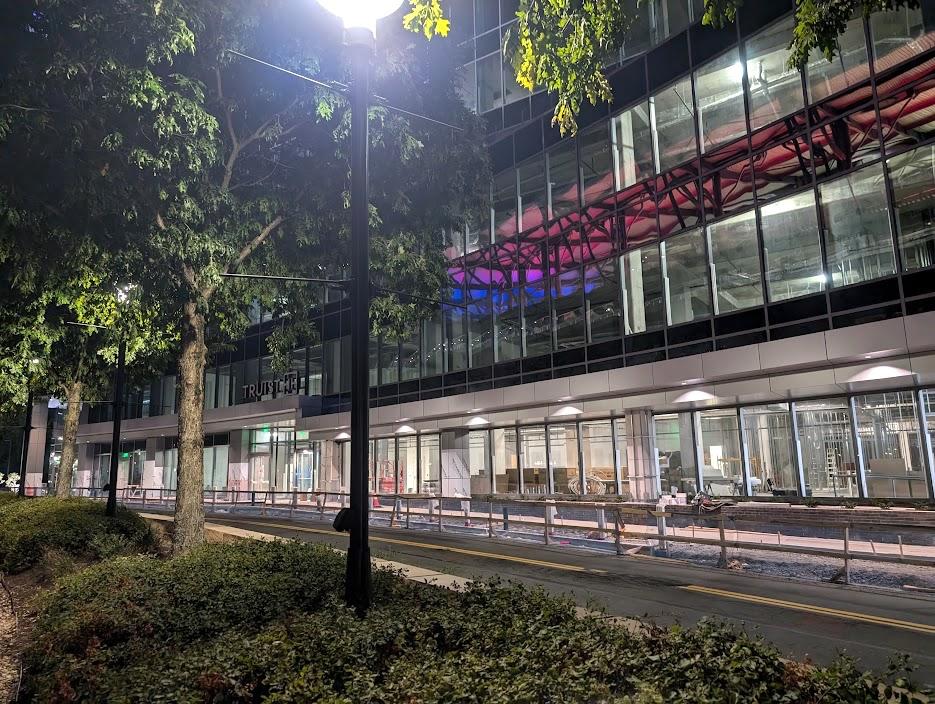
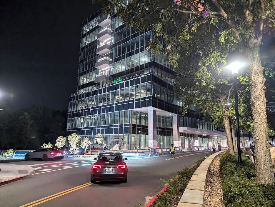
Study: Atlanta national leader in return-to-office growth. Really? Josh Green Thu, 09/12/2024 - 13:39 Does it seem like your neighbors and their neighbors and the cousins of all those neighbors now work from home at least part of the week? In Atlanta’s case, looks might be deceiving, according to a new analysis of top U.S. office markets.  

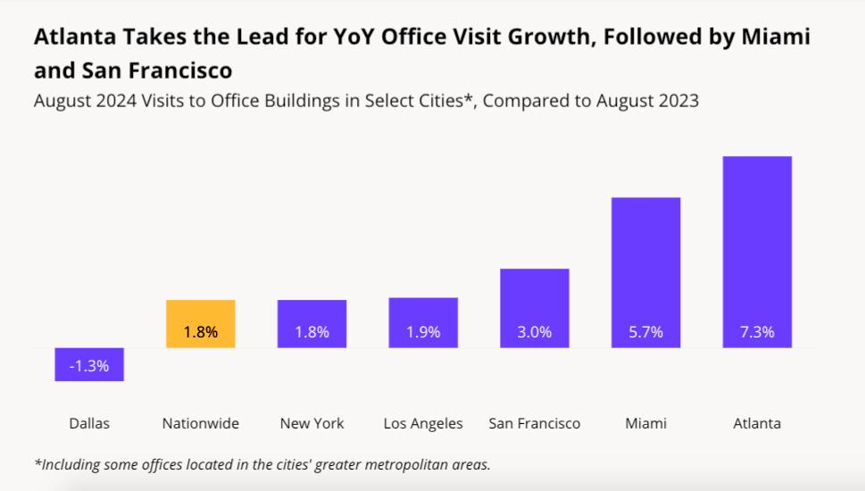
Office foot traffic has remained near post-pandemic highs in major markets during the final weeks of summer, and Atlanta is leading the charge in terms of year-over-year office visit growth among the largest cities in the country, according to location analytics company Placer.ai.

Since August 2023, visits to offices in Atlanta (with some suburban job centers included) have grown by 7.3 percent. If that number seems unimpressive, consider that nationwide the growth was just 1.8 percent over the same time period, according to the Placer.ai Office Index: August 2024 Recap.

Why so? Analysts noted that major Atlanta employers including UPS and the Centers for Disease Control and Prevention have helped the city’s ranking by enforcing stricter in-office policies in 2024, four years after pandemic lockdowns and the WFH zeitgeist took hold.

Another factor, as analysts noted, is several large deals that led to a surge in office leasing activity in the early months of 2024; those leases totaled 2.4 million square feet in metro Atlanta—or 71 percent more than the first quarter of 2023.

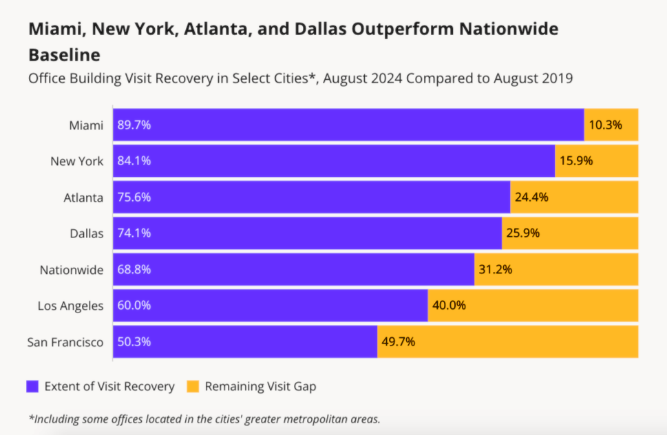
Overall, Atlanta’s office visits in August were nearly 76 percent of what they were in August 2019—good for third place among 11 cities studied.

Only Miami and New York, respectively, have seen stronger return-to-office numbers.

Placer.ai Office Index: August 2024

Of course, the outlook isn’t entirely rosy.

Office visits nationwide remain down more than 31 percent over what they were five years ago, per Placer.ai data. According to Colliers, many office occupiers in Atlanta continue to give back space, leading to six consecutive quarters of negative net absorption in the market, with the overall vacancy rate ending the second quarter of 2024 at a new high of 20 percent.

Placer.ai analyzed major markets spread across the country—Miami, New York City, Atlanta, Dallas, Washington D.C., Boston, Chicago, Denver, Los Angeles, Houston, and San Francisco—and included foot traffic data at roughly 1,000 office buildings. (Mixed-use buildings with both commercial and residential uses were excluded, for obvious reasons.)

Placer.ai Office Index: August 2024

In terms of who is heading back to offices, the data point to a dip in the number of households with children with RTO schedules, as flexibility remains at a premium for those groups.

Conversely, the share of one-person households and young professionals returning to offices has spiked. “Whether driven by a desire to embrace in-office career growth and mentorship opportunities,” notes the Placer.ai recap, “or by a craving for more social interaction, these employees are returning to the office in ever greater numbers.” 

...

Follow us on social media:

Twitter / Facebook/and now: Instagram  

Atlanta declared No. 2 most livable city in U.S. for 2024 (Urbanize Atlanta) 

Tags

Placer.ai Office Index Placer.ai Market Studies Urban Studies Atlanta Trends Office Trends Trends Atlanta Studies Office Space Atlanta Office Market Atlanta Office Space Market Analysis Colliers

Images

Placer.ai Office Index: August 2024

Placer.ai Office Index: August 2024

Subtitle Georgia’s capital led year-over-year analysis as office visit levels edge back toward 2019 numbers

Neighborhood Citywide

Background Image

Image A skyline photo of Atlanta under blue skies with many tall buildings and highways and mountains in the far distance.

Before/After Images

Sponsored Post Off


Rent prices unveiled at Midtown's newest deluxe apartment tower Josh Green Thu, 09/12/2024 - 08:09 After breaking ground with a substantial demolition project in early summer 2022, Midtown’s newest high-rise community is revealing what it will cost to live there when apartments start delivering in coming weeks.

Standing 28 stories with a flat-fronted, rectangular façade near the High Museum of Art, the Loria Ansley project marks the last of three luxury residential towers that have recently injected nearly 1,000 non-student apartments into Midtown’s northern blocks.

Officials with the 1441 Peachtree St. project say Loria Ansley will offer 23 different floorplans, with two distinctive interior finish collections.

None of the 350 apartments are reserved as affordable or workforce housing, as the Midtown location is exempt from Beltline inclusionary zoning rules or any other measures that mandate such units be included. Two months of free rent, however, is being offered with leases of 14 months or longer

Getting a foot in the door at Loria Ansley costs $1,546 monthly right now. That rents a studio unit with 470 square feet and a single bathroom.

The least expensive two-bedroom, one-bathroom floorplan currently available (976 square feet) is $2,963 monthly.

The least expensive one-bedroom (at left) and two-bedroom options currently leasing at Loria Ansley. Loria Ansley

How the apartment building's retail component is expected to meet Peachtree Street. Loria Ansley

Moving up the scale, available three-bedroom, two-bathroom apartments are renting from $3,696 monthly for 1,277 square feet.

And the largest and priciest option listed to date—asking $6,849 monthly—has three bedrooms (one marketed as a possible den) and two bathrooms in 1,738 square feet. That includes a home office space attached to the primary suite.

The building is described as offering “unparalleled elegance and lavish amenities” and “a sanctuary where every detail has been thoughtfully curated,” with finishes such as gourmet kitchens and LED lighting packages found in high-end condo buildings, per developers. Some apartments will include under-counter wine coolers and customizable closets, while all have wall-mounted range hoods in kitchens, washers and dryers, and “hardwood-inspired luxury plank flooring,” per the project’s website.

Loria Ansley's largest floorplan listed to date, asking $6,849 monthly. Loria Ansley

The building's stair-stepped eastern face, overlooking Ansley Park. Courtesy of Atlantic Residential

Amenity levels have been placed among a stair-stepped design leading down toward residential Ansley Park on the backside of the building. Two restaurant spaces at the lobby level will include large glass windows and tall ceilings. Elsewhere, an internal sky bridge will lead to collaborative and private coworking spaces, a gym, wine bar, pool with sundeck and cabanas, a rooftop bar and lounge with views from Buckhead to Midtown, and now, yes, pickleball, according to developers.

Other perks include a 24/7 concierge, a yoga lawn, and an Impulsify “Grab & Go” market. A rather unique draw is the building’s complimentary coffee bar, which will serve cold brew and kombucha on tap for residents.

Loria Ansley replaced internet company EarthLink’s former low-rise offices. The multi-firm project—formerly known as Rhapsody—was initially expected to include for-sale condos but switched to apartments before construction took off.

Capital City Real Estate bought the 1.5-acre property from EarthLink in 2019 for $15.2 million. The Washington, D.C.-based developer is partnering with Atlantic Residential, FIDES Development, and Mitsui Fudosan America, the U.S. subsidiary of Japan's largest real estate company, on the project.

Beyond apartments, the project will include 463 parking spaces and 3,000 square feet of retail space at street level, according to Midtown Alliance. No tenants for retail spaces have been announced.

Marketing materials promise a location where renters can draw inspiration from “both the modern energy of Atlanta’s iconic Arts District and the roots that run deep throughout historic Ansley Park.”

Loria Ansley marks the third luxury rental tower to rise within a few blocks over the past two years, following Greystar’s Nomia building and JPX Works’ new Emmi Midtown project.

All told, those projects are introducing 957 market-rate rentals near Midtown’s northern border.

Find a closer look at plans for the (almost) finished Peachtree Street tower in the gallery above.

...

Follow us on social media:

Twitter / Facebook/and now: Instagram  

• Midtown news, discussion (Urbanize Atlanta) 

Tags

1441 Peachtree Street NE Loria Ansley Atlantic Residential FIDES Development Capital City Real Estate Mitsui Fudosan America Atlanta Development Atlanta Construction High Museum of Art Piedmont Park Ansley Park Atlanta apartments Rhapsody Earthlink Midtown Skyline Atlanta Skyline Atlanta Renting Atlanta Rents Renting in Atlanta New Apartments New Atlanta Rentals Impulsify

Images

Loria Ansley's 1441 Peachtree location in the northern blocks of Midtown. Google Maps

How the apartment building's retail component is expected to meet Peachtree Street. Loria Ansley

How Loria Ansley's west-facing facade turned out, as seen in June over Peachtree Street. Josh Green/Urbanize Atlanta

Loria branding at the tower's upper floors over Peachtree Street. Atlantic Residential

The property's planned pool and sundeck above parking levels. Courtesy of Atlantic Residential

The building's stair-stepped eastern face, overlooking Ansley Park. Courtesy of Atlantic Residential

Retail and lobby arrangement along Peachtree Street. Courtesy of Atlantic Residential

Planned lighting scheme of the flat-fronted 1441 Peachtree Street building. Courtesy of Atlantic Residential

Location where demolition started in spring 2022 for the 1441 Peachtree apartment building. Google Maps

Loria Ansley's largest floorplan listed to date, asking $6,849 monthly. Loria Ansley

The least expensive one-bedroom (at left) and two-bedroom options currently leasing at Loria Ansley. Loria Ansley

Subtitle At amenity-packed Loria Ansley, $1,546 monthly gets a foot in the door

Neighborhood Midtown

Background Image

Image A rendering of a tall new apartment building with a flat face overlooking Peachtree Street in Atlanta, with stairstep architecture behind it.

Associated Project

1441 Peachtree Street

Before/After Images

Sponsored Post Off


Big multi-tower project enters pipeline near Braves Stadium, Battery Josh Green Wed, 09/11/2024 - 13:29 A development proposal once envisioned as a new gateway into the City of Smyrna near the Atlanta Braves’ mixed-use mecca has grown significantly larger behind the scenes—to the tune of nearly a half-billion dollars in expected project costs.

That’s according to filings made this week by Roswell-based developer RASS Associates with the Georgia Department of Community Affairs that outline what’s now called “South Spring,” a proposed multi-building hub within walking distance of The Battery Atlanta.

South Spring would rise from vacant land the city has long eyed for economic development at 2800 and 2810 Spring Road in Smyrna, where another, smaller project called The Emerson Center was put together by the same developer as the pandemic ebbed in 2021.

The main two structures at South Spring would rise up to 20 stories and include 650 multifamily units. That would be surrounded by a 10 to 12-story structure with a mix of 250 hotel rooms and roughly 200,000 square feet of offices.

Elsewhere, plans call for two buildings standing two stories with 175,000 square feet of commercial space, in addition to a public plaza and park area, according to the DRI filing.

Beneath all of it would be a 1,700-space, underground parking garage that one development official described to the AJC this week as being like “Atlantic Station on steroids."

Proposed location of the South Spring site in relation to Truist Park's mixed-use district and other Cobb County landmarks. Google Maps

The DRI filing, submitted Monday, is an initial step required by the state for developments large enough in scale to potentially impact local governments. Tentative plans call for finishing the project in 2028, per that paperwork.

The 8.7-acre site is near the point where U.S. Highway 41 crosses under Interstate 285, about a mile southwest of Truist Park’s gates. The property has been cleared of low-rise buildings between Holiday Inn Express Atlanta Galleria and the iFly Indoor Skydiving facility, near the Cumberland/Galleria district.

As the AJC reports, RASS Associates’ more vertical plans are projected to cost $492 million just down the road from the mixed-use growth spurt underway outside the walls of the Braves’ ballpark. Developers told the newspaper their goal is to complement and not compete with The Battery, while also capitalizing on buzz and investment in the broader Cumberland area.

Smyrna city officials have annexed most of the property in hopes of creating a new front door and would need to approve zoning to allow for buildings over 95 feet tall—a process that isn’t expected to start until early 2025, once the DRI application is vetted by the state, according to the AJC. (The publication has posted preliminary renderings for South Spring here.) 

The 8.7-acre property in August, as seen looking north on Spring Road toward The Battery Atlanta. Google Maps

Should the South Spring project move forward as planned, it would be significantly more ambitious than the $125-million vision put forward in 2021.

Back then, RASS Associates’ scope called for an eight-story Hilton with 188 rooms, one five-story apartment complex, about 37,000 square feet of space for shops and restaurants, and a 546-space parking garage to service it all.          

...

Follow us on social media:

Twitter / Facebook/and now: Instagram  

• Smyrna news, discussion (Urbanize Atlanta)

Tags

2810 Spring Road Smyrna South Spring Development of Regional Impact City of Smyrna 2800 Properties LLC Georgia Department of Community Affairs Perimeter I-285 Interstate 285 Rass Associates Cobb County Atlanta Suburbs Cobb County Development Truist Park The Battery iFly Indoor Skydiving Holiday Inn Express Atlanta Galleria Smyrna Development OTP

Images

Proposed location of the South Spring site in relation to Truist Park's mixed-use district and other Cobb County landmarks. Google Maps

The 8.7-acre property in August, as seen looking north on Spring Road toward The Battery Atlanta. Google Maps

Subtitle Revised, half-billion-dollar “South Spring” proposal calls for towers up to 20 stories, offices, hotel, more

Neighborhood Smyrna/Vinings

Background Image

Image A large new development site with razed buildings in suburban Atlanta near two wide roads, under blue skies.

Before/After Images

Sponsored Post Off


Large shelter expansion is full speed ahead near Georgia Aquarium Josh Green Wed, 09/11/2024 - 08:08 Construction is barreling ahead on another downtown project aiming to take in Atlanta’s most vulnerable populations from the streets and help get them on tracks to more sustainable lives.

Like the city’s first rapid temporary housing initiative The Melody, and another modular-housing proposal in Mechanicsville detailed by Mayor Andre Dickens last week, the Salvation Army has embarked on a major expansion of its longstanding facilities just north of Centennial Olympic Park. It’s called the Center of Hope.

A Salvation Army of Metro Atlanta capital campaign, HOPE with Dignity, raised funds to expand the organization’s Red Shield Services homeless shelter at 400 Luckie St. into a more comprehensive, modernized Center of Hope campus. The current facility is cramped and doesn’t have enough space to adequately separate male and female residents, which has prompted safety concerns, according to project supporters.

The 46,000-square-foot Center of Hope will stand five stories where Marietta Street meets Mills Street, about a block from the Georgia Aquarium.

Construction progress on the Salvation Army expansion at the corner of Marietta and Mills streets, as seen Saturday. Josh Green/Urbanize Atlanta

According to Invest Atlanta, the project will double the size of the Salvation Army’s current downtown building. It will house the organization’s emergency and transitional living shelter facility, boosting the number of beds from 321 today to 437. Plans call for two floors of dormitory-style housing for male residents, and another two floors of individualized living spaces.

Another component will be a Salvation Army Education and Workforce Development Center with a computer lab and six classrooms, plus study and collaboration areas.

That center will offer services to residents such as housing solutions, financial education, emergency assistance programs, and other specialized programs designed to support veteran services. (A portion of the new beds will be reserved specifically for military veterans.)

Six-story facade plans where Marietta Street meets Mills Street downtown. Salvation Army/HOPE with Dignity; via Invest Atlanta

The Salvation Army's facility at the corner of Luckie and Mills streets today. Google Maps

The addition will allow for Salvation Army’s current facilities to be dedicated to women and families, easing concerns caused by overcrowding.

Invest Atlanta’s board approved a $2 million Westside Tax Allocation District Ascension Fund Grant to help the project get off the ground last year. Additional funding was sourced from Atlanta Emerging Markets ($15 million), investment firm Dudley Ventures ($9 million), and Truist Community Development Enterprises, ($4 million).

According to Dudley Ventures, the expansion project will create 23 full-time jobs in an area with a 47 percent poverty rate—and an unemployment rate of nearly 24 percent. During the intake process, all unemployed residents at the Center of Hope will be connected with the facility’s workforce development center, which will partner with local job placement agencies, per the firm.

The Center of Hope is scheduled to be complete next year, according to the Atlanta Downtown Improvement District.

The 400 Luckie Street location just north of Centennial Olympic Park. Google Maps

...

Follow us on social media:

Twitter / Facebook/and now: Instagram  

• Downtown news, discussion (Urbanize Atlanta)

Tags

400 Luckie Street NW Salvation Army Center for Hope Salvation Army Westside Tax Allocation District Atlanta Development Downtown Development Luckie Street Georgia Aquarium Atlanta Homeless California Homeless Housing Needs Assessment Homelessness Centennial Olympic Park Red Shield Services Dudley Ventures Salvation Army of Metro Atlanta Atlanta Emerging Markets Truist Community Development Enterprises downtown construction Center of Hope Salvation Army Center of Hope

Images

Construction progress on the Salvation Army expansion at the corner of Marietta and Mills streets, as seen Saturday. Josh Green/Urbanize Atlanta

The 400 Luckie Street location just north of Centennial Olympic Park. Google Maps

The Salvation Army's facility at the corner of Luckie and Mills streets today. Google Maps

Six-story facade plans where Marietta Street meets Mills Street downtown. Salvation Army/HOPE with Dignity; via Invest Atlanta

Subtitle Salvation Army project to provide more beds, workforce development center, other support features

Neighborhood Downtown

Background Image

Image An image showing a large brick Salvation Army building under blue skies with cars in front in Atlanta.

Associated Project

Center of Hope

Before/After Images

Sponsored Post Off


Large swath of downtown Atlanta hits open market. Any big ideas? Josh Green Tue, 09/10/2024 - 15:36 A substantial swath of downtown Atlanta where mega-project dreams recently went bust is back on the open market, with sellers hoping to capitalize on the cachet of what they’re calling downtown’s “Ring of Fire.”

Atlanta-based investment firm SSG Realty Partners has listed for sale a 10-acre redevelopment site at the intersection of Ted Turner Drive and Whitehall Street in South Downtown, situated just north of Interstate 20.

The property is where an ambitious, multi-block proposal called Forge Atlanta gained momentum two years ago before tumbling into foreclosure.

That Urbantec Development Partners project—initially called Artisan Yards—was envisioned as a state-of-the-art, life sciences-focused replacement for underused industrial property just east of Castleberry Hill.

The 10-acre site where Ted Turner Drive meets Whitehall Street in the broader context of downtown. Courtesy of SSG Realty Partners

Cancelled plans for Forge Atlanta, looking east toward Summerhill. Courtesy of Urbantec Development Partners

The site was formerly the distribution center for Gourmet Foods International, which relocated to a larger facility in Decatur several years ago, setting the stage for redevelopment that has yet to find footing.

GFI has hired SSG Realty Partners to sell the old distribution center property. Reps tell Urbanize Atlanta the asking price is $86 per square foot. The property owner is listed as McCall Railroad LLC, which was the lender for the Forge Atlanta project.

The acreage is immediately south of the former Gulch property where CIM Group’s Centennial Yards has begun transforming a 50-acre slice of downtown with new ground-up development. Atlanta Ventures’ South Downtown holdings and renovation endeavors are just north of the site, and sellers note other walkable attractions in the area including Mercedes-Benz Stadium, State Farm Arena, and the Reverb by Hard Rock Hotel. 

An SSG announcement calls the area downtown’s “Ring of Fire” and “one of the most dynamic development corridors in the Southeastern U.S.,” in that it’s undergoing more than $10 billion in investment, per the sellers’ estimates.  

“This site offers an unparalleled redevelopment opportunity in one of the most active and rapidly evolving areas of downtown Atlanta,” Peyton Stinson, SSG’s director of residential land group, said in the announcement. “[D]evelopers have a unique chance to shape the future of this vibrant, high-growth district.”

Closer look at the acreage in question, just north of Interstate 20. Courtesy of SSG Realty Partners

How the 10-acre Forge Atlanta project could have lorded over I-20, as seen looking west, toward West End.Courtesy of Urbantec Development Partners

The 10-acre property was purchased by Urbantec for $26 million in early 2021, before going back to its lender early last year.

The vision called for Forge Atlanta, once fully built, to span some 3.8 million square feet.

Included in that mix would have been 1.2 million square feet of residential space, offices, a hotel, an entertainment venue, and a new hub for Atlanta’s life sciences sector. (That scope, for context, would have more than doubled the size of State Farm's three-tower regional headquarters in Dunwoody, another transit-connected development near major Atlanta highways.) 

Forge Atlanta's former site plan, illustrating possible building arrangements, uses, and a potential "Highline" pedestrian bridge link to Castleberry Hill. Urbantec Development Partners; designs, Nelson Wakefield Beasley & Associates; via Office of Zoning and Development/submitted

According to early site plans, Forge Atlanta would have erected seven buildings around a central plaza, with a potential pedestrian bridge spanning active railroad lines to Castleberry Hill. Virtually all of the site, as designers noted, has quick access to MARTA’s Garnett station and Interstate 20.

So, Atlanta: now what?

...

Follow us on social media:

Twitter / Facebook/and now: Instagram  

• Downtown news, discussion (Urbanize Atlanta)

Tags

Ted Turner Drive at Whitehall Street CBRE Forge Atlanta Urbantec Development Partners The Forge MARTA Garnett station Artisan Yards The Gulch Nelson Wakefield Beasley & Associates MARTA Cushman & Wakefield 222 Mitchell Street SW Kimley-Horn Kimley-Horn & Associates Morris Manning & Martin Jae Kim Dallas Fortune 500 SSG Realty Partners Gourmet Foods International Ring of Fire Centennial Yards McCall Railroad LLC McCall Railroad

Images

The 10-acre site where Ted Turner Drive meets Whitehall Street in the broader context of downtown. Courtesy of SSG Realty Partners

Closer look at the acreage in question, just north of Interstate 20. Courtesy of SSG Realty Partners

Forge Atlanta's former site plan, illustrating possible building arrangements, uses, and a potential "Highline" pedestrian bridge link to Castleberry Hill. Urbantec Development Partners; designs, Nelson Wakefield Beasley & Associates; via Office of Zoning and Development/submitted

Cancelled plans for Forge Atlanta, looking east toward Summerhill. Courtesy of Urbantec Development Partners

The former Forge Atlanta proposal as seen from over Interstate 20. Urbantec Development Partners; designs, Nelson Wakefield Beasley & Associates; via Office of Zoning and Development/submitted

How the 10-acre Forge Atlanta project could have lorded over I-20, as seen looking west, toward West End.Courtesy of Urbantec Development Partners

Subtitle Sellers: 10-acre site near Centennial Yards "positioned as major mixed-use development opportunity"

Neighborhood Downtown

Background Image

Image An aerial photo showing a large portion of South Downtown Atlanta in colored circles and yellow highlights near pro sports stadiums.

Before/After Images

Sponsored Post Off


Images: Three cheers for Georgia Tech's extensive new cycle track Josh Green Tue, 09/10/2024 - 13:14 As fall classes and full football schedules return, an extensive infrastructure project through Georgia Tech is hitting its stride, with a goal of building a pedestrian and bicycling route between Midtown and the western fringes of campus with links to other pathways.

The Ferst Drive Realignment and Cycle Track is part of nearly 2.5 miles of new bicycle infrastructure that’s going in across campus—an effort to maintain Georgia Tech’s status as a Gold-level Bicycle Friendly University, as determined by the League of American Bicyclists.

Construction on the cycle track kicked off in December; as a recent tour on two wheels proved, just under a mile of the roadway is under construction today, with more to come.

On the western side of campus, construction starts today near Georgia Tech’s Exhibition Hall and Campus Recreation Center. Its ends, for now, on Ferst Drive at Fowler Street, about two blocks from the Fifth Street Plaza park built over the downtown Connector.  

Milling and paving work is ongoing across the cycle track route, which remains closed to the public.

A stretch of bike lanes separated by median buffers. Josh Green/Urbanize Atlanta

An approximation of the Ferst Drive areas under construction now (at left), and a detailed look at the phase three realignment and PATH connection that began construction in July. Google Maps; Georgia Tech

Clearly, the Ferst Drive cycle track will provide a safer and smoother east-west connection across the city, especially when linked with other people-friendly infrastructure projects. The goal, according to Georgia Tech, is to “provide improved bicycle infrastructure and allow for separation between bikes, pedestrians, and vehicles” along the key corridor. Exactly how the safe the cycle track will be—with permanent concrete barriers, curbs, and other measures—remains to be seen.

Phase 3 began construction in July toward the western side of campus.

That includes a realignment of Ferst Drive at Regents Drive, which project leaders say will allow for a traffic signal to be removed at the intersection. That’s also where the cycle track will link with the award-winning PATH Parkway project that connects downtown to shops, restaurants, and hundreds of residences in the Marietta Street and Howell Mill Road corridors.

Where the cycle track approaches Georgia Tech's sustainable Kendeda "Living" Building, at left. Josh Green/Urbanize Atlanta

Phase 4 of the project will link it to the aforementioned Fifth Street Plaza over the Connector—and just east of there, to the planned 5th Street Complete Street that will extend across Midtown.

According to Midtown Alliance,  the 5th Street Complete Street project is under construction in blocks near Peachtree Street but has yet to make its way to the side of the subdistrict near Georgia Tech.  

The entire Ferst Drive project is scheduled to be completed in early 2025, according to Georgia Tech.

Concrete separation measures between vehicle and bike lanes near State Street. Josh Green/Urbanize Atlanta

For a quick tour of where Ferst Drive improvements stand today, starting on the western side of campus and heading toward the heart of Midtown, pedal up to the gallery above.  

...

Follow us on social media:

Twitter / Facebook/and now: Instagram  

• Georgia Tech news, discussion (Urbanize Atlanta) 

Tags

Georgia Tech Cycle Track Georgia Tech Cycle Track Atlanta Bike Infrastructure Atlanta Bike Lanes Alternate Transportation Alternative Transportation Atlanta Bicycling Bicycling Bicycling Infrastructure GT Georgia Tech Construction Ferst Drive Ferst Drive Bike Lanes Georgia Tech projects Midtown Alliance Mac Nease Baseball Park Russ Chandler Stadium PATH Parkway League of American Bicyclists

Images

Where Ferst Drive realignment construction begins today on the western side of campus, heading east toward the Connector. Josh Green/Urbanize Atlanta

Josh Green/Urbanize Atlanta

A stretch of bike lanes separated by median buffers. Josh Green/Urbanize Atlanta

Ferst Drive changes near the CRC. Josh Green/Urbanize Atlanta

Josh Green/Urbanize Atlanta

Josh Green/Urbanize Atlanta

Where the cycle track approaches Georgia Tech's sustainable Kendeda "Living" Building, at left. Josh Green/Urbanize Atlanta

Concrete separation measures between vehicle and bike lanes near State Street. Josh Green/Urbanize Atlanta

Josh Green/Urbanize Atlanta

Josh Green/Urbanize Atlanta

Josh Green/Urbanize Atlanta

Josh Green/Urbanize Atlanta

Josh Green/Urbanize Atlanta

Josh Green/Urbanize Atlanta

Where Ferst Drive cycle track construction ends today at Fowler Street, near Mac Nease Baseball Park at Russ Chandler Stadium. Josh Green/Urbanize Atlanta

An approximation of the Ferst Drive areas under construction now (at left), and a detailed look at the phase three realignment and PATH connection that began construction in July. Google Maps; Georgia Tech

Subtitle Ferst Drive project to provide safer east-west connection from Midtown

Neighborhood Georgia Tech

Background Image

Image An image of a large new bicycle lane being built through a college campus in the middle of Atlanta near a huge interstate.

Before/After Images

Sponsored Post Off


Crane watch: New tower shines outside Braves' Truist Park Josh Green Tue, 09/10/2024 - 08:06 A literal bright spot on the Atlanta Braves’ injury-riddled 2024 season is rounding into shape near home plate.

Braves Development Company, the team’s real estate arm, has activated a vibrant light scheme for a new office tower complex that’s part of a mixed-use growth spurt beyond the 41,000-seat MLB ballpark’s walls at The Battery Atlanta.

The two-building, Class A office project under development now (a variation from initial renderings shared in 2022) will serve as the new national headquarters for Truist Securities, Truist’s full-service corporate and investment bank.

Earlier this year, the 250,000-square-foot office building topped out at nine stories on the northwest side of Truist Park, up the street from the orange parking deck and Coca-Cola Roxy music venue. An adjoining parking deck with 750 spaces has also been erected.

Multicolored light scheme over the main office portion of Truist Securities new national headquarters. Josh Green/Urbanize Atlanta

Location (starred) of the new Truist Securities complex in relation to the ballpark and mixed uses around The Battery Atlanta. BatteryAtl.com

Braves Development Company officials have said the project remains on schedule to be completed later this year, with Truist employees moving in sometime in 2025. At the outset, those employees will occupy only about half of the building, according to terms of the 15-year leasing deal.

The idea is that Truist will have the option to house more employees and grow its business presence at The Battery over time.

The office building will eventually house about 1,000 Truist Securities employees, roughly 300 feet behind the ballpark. Also in the plans is a 42,000-square-foot trading floor, officials have said. 

Where work continues on base levels of the main office building. Josh Green/Urbanize Atlanta

Where the project's 750-space parking deck abuts the main office building. Josh Green/Urbanize Atlanta

Billed as “Atlanta’s Premiere Entertainment District,” The Battery totals more than 2.25 million square feet of development today. Truist Securities’ headquarters isn’t the only substantial project in the district’s pipeline.

two-tower project called “The Henry”—an homage to late Braves legend Hank Aaron—is in development with infrastructure work beyond Truist Park’s left and centerfield walls. The Henry’s plans call for a mix of more than 500 upscale apartments, a 250-key Marriott Autograph hotel, retail space, and 54 condos, the latter representing a rare for-sale residential option for the district.

Also nearby, plans emerged earlier this year for a 13-story office project that could take shape between the ballpark and Cobb Cloverleaf as an expansion of the three-building Circle 75 Office Park.

Meanwhile, on the flipside of the stadium, an apartment venture called Ellison Parkview has opened on Windy Ridge Parkway, claiming what used to be 4 acres of hilly woods about a block west of the ballpark. It includes 298 rentals, 6,000 square feet of space for restaurants and retail, and a new rideshare pick-up and drop-off area.

One-bedroom rents at Ellison Parkview start at $1,790 per month (for 597 square feet) right now, while some of the largest units (1,557 square feet) are commanding north of $5,800 monthly.

The portion of the building along Hank Aaron Way, an entry/exit at the northernmost point of The Battery. Josh Green/Urbanize Atlanta

Initial plans for how the project would look from Truist Park's entrance behind home plate, according to 2022 renderings. Braves Development Company; designs, Nelson Worldwide

Swing up to the gallery for a closer look at The Battery’s latest addition and more project context.

...

Follow us on social media:

Twitter / Facebook/and now: Instagram  

• Smyrna news, discussion (Urbanize Atlanta)

Tags

800 Battery Avenue SE Truist Securities tower The Battery Atlanta Braves Development Company Atlanta Braves Smyrna Cobb County Vinings MLB Mixed-Use Development Atlanta Development Atlanta Construction Truist Financial Corporation Truist Securities Cumberland CID Office Space Nelson Worldwide Nelson Architects Brasfield & Gorrie Brasfield and Gorrie JLL Uzun+Case exterior design lighting Crane Watch

Images

Location (starred) of the new Truist Securities complex in relation to the ballpark and mixed uses around The Battery Atlanta. BatteryAtl.com

Multicolored light scheme over the main office portion of Truist Securities new national headquarters. Josh Green/Urbanize Atlanta

Where work continues on base levels of the main office building. Josh Green/Urbanize Atlanta

Where the project's 750-space parking deck abuts the main office building. Josh Green/Urbanize Atlanta

The portion of the building along Hank Aaron Way, an entry/exit at the northernmost point of The Battery. Josh Green/Urbanize Atlanta

Parking garage facing the northernmost point of the MLB ballpark. Josh Green/Urbanize Atlanta

Proximity of the Truist building to the brick-clad ballpark, at right. Josh Green/Urbanize Atlanta

Josh Green/Urbanize Atlanta

As shown prior to groundbreaking, the property along Battery Avenue where Truist Securities' new national headquarters has topped out. Braves Development Company

The Truist Securities office project, in relation to the MLB ballpark, as shown after it had topped out last spring. Courtesy of Atlanta Braves/Braves Development Company

Initial plans for how the project would look from Truist Park's entrance behind home plate, according to 2022 renderings. Braves Development Company; designs, Nelson Worldwide

Subtitle Behind home plate, two-building Truist Securities project enters home stretch of construction

Neighborhood Smyrna/Vinings

Background Image

Image A photo of a new tower location outside the brick walls of the Atlanta Braves ballpark near wide streets.

Associated Project

800 Battery Avenue SE

Before/After Images

Sponsored Post Off


Townhome project in pipeline near popular eastside park Josh Green Mon, 09/09/2024 - 16:08 The trend of building townhomes on vacated or wooded properties in Edgewood and Kirkwood is set to continue along a main thoroughfare for both neighborhoods.

According to City of Atlanta Department of City Planning records, a five-unit townhome project is moving forward at the southeast corner of Hosea L. Williams Drive and Montgomery Street.

The wooded site is less than a block from Kirkwood’s Coan Park, a popular eastside greenspace for recreation, sports, and events along PATH’s Eastside Trolley Trail.

Details remain scare, but according to initial filings with the city, plans call for five attached townhomes at the site that would merge five lots into one, near the point where Kirkwood meets Edgewood.

The corner site in question near Coan Park and Kirkwood's westernmost flank. Google Maps

Signage posted at the site in August indicates a stream buffer encroachment is involved, regarding a creek that cuts through a portion of the site before heading south toward Memorial Drive.

The project would be a relative anomaly for Hosea Williams Drive in the area, an important east-west thoroughfare that’s mostly lined with single-family homes.

In recent years, however, townhomes have cropped up in several projects across more northern blocks of both Kirkwood and Edgewood—especially near Pullman Yards—and also in numerous places along the Memorial Drive corridor.

The five parcels along Hosea Williams Drive in March last year. Google Maps

...

Follow us on social media:

Twitter / Facebook/and now: Instagram  

• Edgewood news, discussion (Urbanize Atlanta) 

Tags

1483 Hosea Williams Drive Coan Park Atlanta Townhomes townhomes Edgewood Townhomes Kirkwood Eastside Trolley Trail Edgewood Kirkwood Townhomes

Images

The corner site in question near Coan Park and Kirkwood's westernmost flank. Google Maps

The five parcels along Hosea Williams Drive in March last year. Google Maps

Subtitle Proposal calls for developing wooded corner where Kirkwood meets Edgewood

Neighborhood Kirkwood

Background Image

Image A corner of a development site under blue skies near wide streets in Atlanta with a sidewalk in front.

Before/After Images

Sponsored Post Off


Yes, new Atlanta homes in high $100Ks exist—and they look like this Josh Green Mon, 09/09/2024 - 13:24 An infill project is moving forward in Southwest Atlanta that’s offering homebuyers a rare opportunity to own a property at below market value, according to developers.

Pre-sales have started for 1070 Dill, or what’s described as a “vibrant living” environment with smaller townhome floorplans starting in the $190,000s for buyers who qualify.

Named for its address on Dill Avenue, 1070 Dill is under construction in Capitol View, near the planned Murphy Crossing commercial and residential village, a few blocks from the Atlanta Beltline’s Westside Trail. The Oakland City MARTA station and Lee + White food and beverage district are also listed as walkable perks in the area.  

The property, formerly home to a small church, abuts two other affordable housing ventures in the area: Gateway Capitol View and 1055 Arden Apartments.

Dill Avenue facades, with a courtyard placed between buildings. 1070Dill.com

The site in question near a MARTA station and the Westside Trail. Google Maps; UA

Site plans indicate the project will include 22 units total, with a courtyard, dog park, and parklet situated between the townhomes. All units at 1070 Dill will have a single bedroom, with patios described as private and shared backyards, per project officials.

The pocket neighborhood’s goal is to create “a community where connecting to neighbors and city life is part of the everyday experience,” per marketing materials.

A sample two-story floorplan, Unit No. 1, shows one bedroom and one bathroom in 640 square feet, with a starting asking price of $194,000.

Household incomes must be below 120 percent of the area median income to qualify for buying at 1070 Dill. Down payment assistance through Invest Atlanta could also be available for some buyers, according to property listings.  

Along with Invest Atlanta, partners on the project are listed as Praxis3 architects, Service 1st Bank, tiny home developer Fortas Homes, and Murphy Crossing developers Culdesac and Urban Oasis.

The project's dog park and parklet, as shown in renderings. 1070Dill.com

Income qualifications listed for 1070 Dill. 1070Dill.com

Site plan for 1070 Dill's 22 units. 1070Dill.com

We’ve reached out to project officials for more information on when 1070 Dill units might be finished, and we’ll update this story with any additional details that come.

Find more context and imagery in the gallery above.

...

Follow us on social media:

Twitter / Facebook/and now: Instagram  

• Capitol View news, discussion (Urbanize Atlanta)

Tags

1070 Dill Ave. SW 1070 Dill MARTA Beltline Westside Trail Atlanta BeltLine Affordable Housing townhomes Atlanta Townhomes For Sale Service 1st Bank Praxis3 Invest Atlanta Urban Oasis Development Culdesac Fortas Oakland City MARTA station Southwest Atlanta Fortas Homes Pocket Neighborhoods

Images

The site in question near a MARTA station and the Westside Trail. Google Maps; UA

The 1070 Dill Ave. property in question before construction began. Google Maps

Site plan for 1070 Dill's 22 units. 1070Dill.com

Dill Avenue facades, with a courtyard placed between buildings. 1070Dill.com

The project's dog park and parklet, as shown in renderings. 1070Dill.com

Floorplans for unit No. 1, starting at $194,000 for 640 square feet. 1070Dill.com

Income qualifications listed for 1070 Dill. 1070Dill.com

Subtitle Project called 1070 Dill is under construction near Beltline’s Westside Trail

Neighborhood Capitol View

Background Image

Image A rendering showing a large new housing development under blue skies in southwest Atlanta near a wide street.

Before/After Images

Sponsored Post Off


‘Pedestrian-oriented’ overhaul of Peachtree Street pitched downtown Josh Green Mon, 09/09/2024 - 08:04 Don’t call it a Complete Street or a return of downtown's erstwhile shared street experiment, but a significant revision for one section of Atlanta’s signature street could be in store near a number of big-ticket private developments.

As part of broader efforts to transform streets across South Downtown, officials with Atlanta Downtown Improvement District are planning a people-friendly redesign for a section of Peachtree Street just south of Five Points and Underground Atlanta.

The project, a partnership with Atlanta Department of Transportation, would focus on Peachtree Street between Alabama Street and southward to Trinity Avenue (Ga. Highway 154). That’s a distance of roughly .3 miles, or three blocks.

The corridor in question includes properties in entreprenuers Atlanta Ventures’ growing South Downtown portfolio, a few blocks east of the ongoing Gulch remake that is Centennial Yards.

The scope of the Peachtree Street project calls for shrinking it from four vehicle travel lanes to two, allowing for reconstructed and widened sidewalks. ADA curb ramps and crosswalks would be upgraded, and new spaces for landscaping and seating would be installed.

A new rendering that shows potential Peachtree Street plans near Martin Luther King Jr. Drive. ATLDOT; CAP/ADID

Extent of the Peachtree Street blocks in question (dotted line). Google Maps

The goal, according to ADID and ATLDOT, is to build a “pedestrian-oriented street with generous sidewalk dimensions designed for flexible use” that implements space for restaurant dining on sidewalks, while leaving room for passenger drop-off zones, commercial deliveries, and other uses.

Designers acknowledge that South Downtown today is at an “inflection point,” and other aspects of the logic behind the Peachtree Street changes could be sweet music to the ears of ATL urbanists:

“[Ongoing investment in the area is] poised to again make the community a vibrant 24-hour neighborhood where Atlantans live, work, and play,” reads a project description. “For South Downtown to thrive, it must be supported by a robust multimodal transportation network where cycling, walking, and transit are convenient and comfortable.

“As streets form the largest cohort of public spaces in the [South Downtown] neighborhood,” the description continues, “roadway investments are also an opportunity to create a more inviting and engaging public realm.”

The street's condition just south of Martin Luther King Jr. Drive in June. Google Maps

Extent of changes planned south of Five Points. Kimley-Horn; ALTDOT/ADID

No bicycle lanes or related infrastructure is proposed on Peachtree Street. The street, however, does cross new protected bike lanes at Martin Luther King Jr. Drive and others on Trinity Avenue.

According to ADID officials, the project’s construction would take roughly 24 weeks total—or eight weeks per block. No timeline for a groundbreaking has been specified.

The project will be paid for through a combination of Federal Highway Administration and ADID funding, per officials.

Want to chime in on the plans above?

As part of the public engagement process, ADID and its partners will hold a Public Information Open House from 5 to 7 p.m. Wednesday at 99 Broad St. downtown to share detailed plans and collect feedback. The open-house style meeting means participants are free to pop in for any amount of time, as no formal presentation will be given.

Scope of the planned changes in a broader context. Google Maps

...

Follow us on social media:

Twitter / Facebook/and now: Instagram  

• Downtown news, discussion (Urbanize Atlanta)

Tags

Atlanta Downtown Improvement District Central Atlanta Progress CAP Atlanta Department of Transportation ATLDOT Peachtree Street South Downtown Atlanta Sidewalks Alabama Street Atlanta Streets Trinity Avenue Atlanta Bike Lanes Bike Lanes Kimley-Horn & Associates Kimley-Horn Kimley Horn

Images

Extent of the Peachtree Street blocks in question (dotted line). Google Maps

A new rendering that shows potential Peachtree Street plans near Martin Luther King Jr. Drive. ATLDOT; CAP/ADID

The street's condition just south of Martin Luther King Jr. Drive in June. Google Maps

Scope of the planned changes in a broader context. Google Maps

Extent of changes planned south of Five Points. Kimley-Horn; ALTDOT/ADID

Subtitle Proposal would subtract car lanes, beef up sidewalks near high-profile projects

Neighborhood Downtown

Background Image

Image An image of a road in downtown Atlanta with many lanes and cars next to two rows of mid-rise buildings.

Before/After Images

Sponsored Post Off


19 images: Amazing greenspace quietly coming together off Beltline Josh Green Fri, 09/06/2024 - 15:44 An under-the-radar greenspace project near the Beltline’s Southside Trail that project leaders call both innovative and beautiful is rounding into shape in compelling ways.

With infrastructure work that brings to mind early stages of Historic Fourth Ward Park, the multifaceted trails and greenspace project in booming Chosewood Park is part of Atlanta Housing’s 30-acre Englewood development, which has begun construction on the first $72-million phase of affordable housing just west of Boulevard.

Atlanta Housing officials provided the latest project renderings and more insight to Urbanize Atlanta this week, shedding light on how the park will look and function.

The park project will connect with Chosewood Park via stairs at Gault Street, and will link with trails to the Southside Trail and the adjacent Beltline Crossing Park, which is expected to eventually be expanded.

Construction progress at the Englewood greenspace project shown in recent weeks south of downtown, with the new Upton apartments in the middle distance. Courtesy of Phil Veasley

Sideview of the park's fountain component. Courtesy of Atlanta Housing

Atlanta Housing breaks down park components into three different sections. Those are described as:

The Fountain: A sustainable stormwater pond and fountain features cover about 3 acres and will serve as “a beautiful amenity to the community,” per an Atlanta Housing spokesperson.

Linear park*: At roughly 1/2 acre, this park will link to the northern part of the Englewood development.*

Tiered streetscapes*: Also known as “town center park,” this 2.5-acre greenspace will be the central activity focal point for the full community. The terrace is designed with plaza seating, lawns, a playground, and shade structure.*

The greenspaces are on pace to be finished by the end of 2024. But according to project leaders, the park won’t open to the public until onsite housing construction is complete.

At last check, the first housing component isn’t expected to open until sometime in 2026.

Proximity of Empire Communities' Zephyr project (bottom) to the multifaceted park. Courtesy of Phil Veasley

Courtesy of Phil Veasley

General location of the parks component (bottom right) at the Englewood development. Atlanta Housing

In the gallery above, find the latest project renderings and a wealth of photography generously provided this week by Atlanta urbanist and engineer Phil Veasley.

...

Follow us on social media:

Twitter / Facebook/and now: Instagram  

• Chosewood Park news, discussion (Urbanize Atlanta)

Tags

Englewood Englewood Development Housing Program Atlanta Housing Englewood Manor Beltline Atlanta BeltLine Southside Trail Peoplestown Chosewood Park Grant Park Boulevard The Michaels Organization The Benoit Group Affordable Housing Atlanta Development senior housing Englewood Senior Berkadia Raymond James Sterling Bank J.M. Wilkerson J.M. Wilkerson Construction Corcoran-Ota Atlanta Parks Parks and Rec Parks and Recreation Atlanta Greenspaces Atlanta Construction

Images

General location of the parks component (bottom right) at the Englewood development. Atlanta Housing

Construction progress at the Englewood greenspace project shown in recent weeks south of downtown, with the new Upton apartments in the middle distance. Courtesy of Phil Veasley

Proximity of Empire Communities' Zephyr project (bottom) to the multifaceted park. Courtesy of Phil Veasley

Overhead perspective on the 3-acre fountain area of the park. Courtesy of Atlanta Housing

Planned look of the linear park. Courtesy of Atlanta Housing

Sideview of the park's fountain component. Courtesy of Atlanta Housing

Pathway that will be public-accessible leading to a main park component. Courtesy of Phil Veasley

Planned look of tiered streetscapes coming together now at the Atlanta Housing development. Courtesy of Atlanta Housing

Courtesy of Phil Veasley

Courtesy of Phil Veasley

Courtesy of Phil Veasley

Courtesy of Phil Veasley

Courtesy of Phil Veasley

Courtesy of Phil Veasley

Courtesy of Phil Veasley

Courtesy of Phil Veasley

Courtesy of Phil Veasley

North view from over the Zephyr project today. Courtesy of Phil Veasley

Courtesy of Phil Veasley

Subtitle Public trails, parks near Southside Trail are part of Atlanta Housing’s Englewood development

Neighborhood Chosewood Park

Background Image

Image An image showing a large new greenspace under construction on the southside of Atlanta under gray skies with tiers and greenspace and a skyline in the distance, with many trees around.

Before/After Images

Sponsored Post Off


Developer: Despite appearances, large Peoplestown project still on Josh Green Fri, 09/06/2024 - 14:12 Anyone who’s walked, ridden, or driven past the longstanding, branded construction fencing at 99 University Ave. lately could assume the sprawling site is idle. But according to a prominent intown development firm, that’s not the case.

Officials with Mill Creek Residential, a national developer that’s built upscale intown apartments from Decatur to Buckhead in recent years, say Modera Southside Trail remains an active and viable project at a former industrial property in Peoplestown, about 2 and ½ miles south of downtown.

Vacant buildings on the 11.4-acre University Avenue site, located just east of the downtown Connector, had previously been used for truck repair and a fueling station. Demolition began about 19 months ago.

“We’ve completed the demolition of the existing structure, and site work is currently in progress,” Phil Carson, Mill Creek’s vice president of development, tells Urbanize Atlanta via email.

The seemingly idle (for now) site at 99 University Ave. in Peoplestown this month, just east of the downtown Connector. Josh Green/Urbanize Atlanta

The apartment community's University Avenue facade, just east of Interstates 75 and 85. Courtesy of Mill Creek Residential; designs, Studio Architects

The project calls for 402 apartments spread across several mid-rise buildings, with a centralized amenity space and surface parking lots in between, a stone’s throw from an under-construction stretch of the Beltline’s Southside Trail. Construction schedules in early 2023 called for opening the first units in the fourth quarter of this year.

Carson says vertical construction at Modera Southside Trail is now on track to start in the second quarter of 2025.

Officials have said 15 percent of Modera Southside Trail apartments—or 61 homes—will be reserved as affordable housing at 80 percent of the area’s median income. (Previous working titles for the project were cease-and-desist magnet “Modera Beltline” and “Modera SoDo.”)

The property also borders the site where 27-year-old Rashard Brooks was fatally shot during an altercation with Atlanta police in June 2020. The drive-through restaurant was set ablaze by protestors and demolished the following month. 

Just east of Mill Creek’s site, more than 1,100 rental townhomes and apartments have recently delivered, or are under construction, on formerly vacant or underused land with Beltline walkability. Those projects include the massive Maverick complex and the Skyline Apartments tower.

Also nearby, adaptive-reuse food hall and office project Terminal South began construction in January.

The Peoplestown site's proximity to downtown and three interstate highways. Google Maps

Overview of the 402-unit project's layout off University Avenue. Courtesy of Mill Creek Residential; designs, Studio Architects

The Beltline section in question—the Southside Trail’s Segments 2 and 3—began full construction this past summer and is scheduled to open in early 2026.  

Swing up to the gallery for more images and context.

...

Follow us on social media:

Twitter / Facebook/and now: Instagram  

• Peoplestown news, discussion (Urbanize Atlanta) 

Tags

99 University Avenue SW Modera Southside Trail Studio Architects Mill Creek Residential Atlanta Development Atlanta Construction Atlanta apartments Rayshard Brooks Wendy’s Beltline Atlanta BeltLine Southside Trail

Images

The seemingly idle (for now) site at 99 University Ave. in Peoplestown this month, just east of the downtown Connector. Josh Green/Urbanize Atlanta

The Peoplestown site's proximity to downtown and three interstate highways. Google Maps

The 11.4-acre property in question, with the Beltline corridor at bottom right, the Connector at left, and the former Wendy's location next door (starred). Fulton County Board of Assessors

The apartment community's University Avenue facade, just east of Interstates 75 and 85. Courtesy of Mill Creek Residential; designs, Studio Architects

Overview of the 402-unit project's layout off University Avenue. Courtesy of Mill Creek Residential; designs, Studio Architects

Josh Green/Urbanize Atlanta

Subtitle Modera Southside Trail calls for hundreds of residential units on former trucking site

Neighborhood Peoplestown

Background Image

Image A rendering of a large new building with balconies and a street mural under blue skies.

Before/After Images

Sponsored Post Off

view more: ‹ prev next ›